Resources
Fuzhen Yin
UCCS Geoviz - Fall 2025
Please come back for more information on resources. This page will be updated frequently to share career opportunities.
Acknowledgement
Thanks to the following people who have provided references to style
and structure this tutorial.
Visualization Ideas
Here are some websites where you can find inspirations and codes for
visualization.
To Create Your Own Website
Data Sources
Opportunities
Research Talk “Shifting Geographies of Insecurity across Sahelian West Africa” by Dr. Steve Radil
Our department will host a research talk by Dr. Steve Radil, a former assistant professor at the Air Force Academy and a leading researcher in political geography. He’ll be presenting on Friday, August 29th, from 11:00 am to 12:30 pm in COLU 329, with the title: “Shifting Geographies of Insecurity across Sahelian West Africa.” Join us for a valuable opportunity to discuss and brainstorm about these important geographic issues.
GISalon webinar: Exploring Career Paths in GIS
Dear colleagues,
GISphere, a non-profit organization dedicated to promoting GIScience, is excited to invite you to our 6th GISalon webinar, titled “Exploring Career Paths in GIS: Local Government and Public Sectors.”
This webinar will feature GIS professionals from local, national, and international agencies. The panelists will discuss their experiences using GIS in solving real-world challenges across fields such as city planning, public health, climate science, and forestry and share valuable advice for current students on securing a job and thriving in the GIS profession.
The webinar is scheduled for Friday, November 15, 2024, at 10:00 AM EST via Zoom: https://zoom.us/my/gisalon. Please see the attached posters for more details.
It would be wonderful if you could help us circulate the event information and attached posters with students in your department, both undergraduate and graduate, and invite them to join– especially those interested in GIS careers in the public sector.
Best,
GISphere team
PhD Opportunity in Dr. Yingjie Hu’s GeoAI Lab at University at Buffalo
Dr. Yingjie Hu’s research group currently has the following opening for Fall 2025 (application deadline is in December 2024).
Fully-funded PhD student: We are looking for 1 PhD student who shares our passion for GIScience and GeoAI, and is interested in research on deep learning, spatial analysis, and disaster resilience. The successful applicant will be fully funded through a combination of scholarships as Research Assistantships (RA), Teaching Assistantships (TA), and/or Fellowships. If you are interested in this PhD student position, please contact Dr. Yingjie Hu by email (yhu42@buffalo.edu) and attach your CV. The department application page is at: http://www.buffalo.edu/cas/geography/about-us/admissions.html.
Mountain Lion Research Day (Presentation on December 6th)

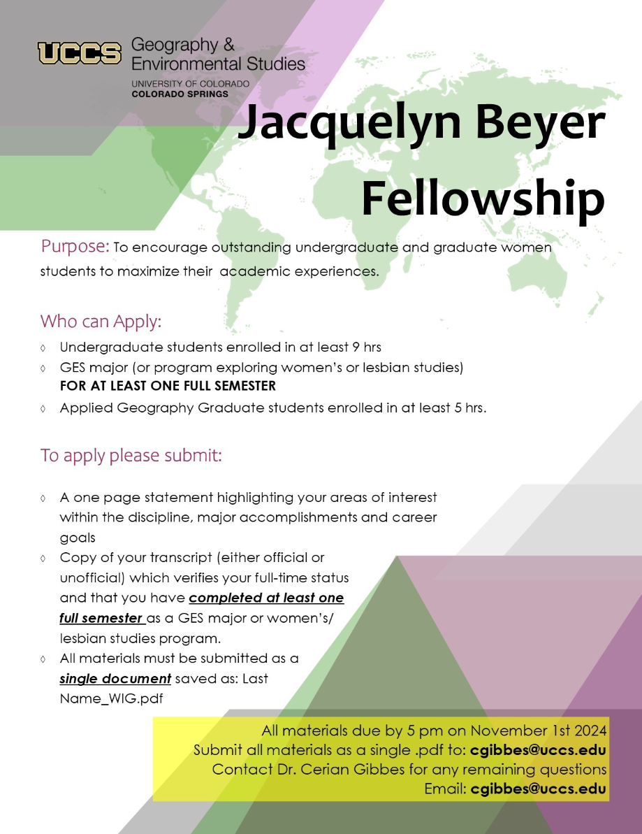
Jacquelyn Beyer Fellowship (ddl: Nov. 1st)
Join the Email list-serv for RA opportunities with Matt Gottfried
Matt has a few upcoming projects working with local communities and organizations (e.g., Pikes Peak Outdoor Recreation Alliance, and Palmer Land Conservancy) using GIS techniques Please email Matt (matthew.gottfried@uccs.edu) to join the listserv.
Penn State’s Graduate Program for fully-funded positions on Cartography and Geovisualization
The Department of Geography at Penn State is welcoming applications in the subfields of Cartography, Geovisualization, and GIScience to its resident Graduate MS & PhD programs. All admitted graduate students at Penn State Geography are fully-funded on either teaching or research assistantships. Multiple externally funded projects in cartography and geovisualization are ongoing and available to support qualified applicants with backgrounds in mapping, visualization, and GIScience. The Department is home to multiple GIScience research centers, including the GeoGraphics Lab. Applications are due December 1, 2024.
Please review our website for full details on how to begin your application: https://www.geog.psu.edu/graduate/graduate-admissions-and-aid/how-apply-our-resident-graduate-program
We invite prospective students to join us for an upcoming webinar information session about our graduate program on Tuesday, October 22nd 5:00pm - 6:00pm EDT. Register here to participate: tinyurl.com/psugeoginfo
Applicants should indicate subfield interests in Cartography, Geographic Information Science, and Spatial Data Science on the application form, as well as suggesting professors Anthony Robinson and Cynthia Brewer as specific people you might work with (these steps will ensure that applicants in cartography/viz are able to be prioritized – it does not require you to work with those advisors). All complete applications that are submitted on or before the application deadline are reviewed by the graduate program admissions committee, made up of faculty spanning the major subfields of geography. This committee works together to review and evaluate all applications, and after developing an overall ranking for the applicant pool, potential advisors listed on the application are brought in to provide additional feedback on top overall candidates.
If you have questions, please contact Anthony Robinson at arobinson@psu.edu.
Project Specialist Opening at University of California Riverside
The School of Public Policy at the University of California, Riverside (UCR), is seeking a highly motivated Postdoctoral Researcher or Project Specialist, depending on qualifications. The successful candidate will work on multiple NSF-funded projects focusing on housing, public health, economic development, and spatial data science. Application review begins on Oct 1, 2024, and will continue until the position is filled.
Special Sworn Status (SSS) is required for researchers to access restricted-use data at the Census Bureau’s Federal Statistical Research Data Centers. Therefore, the final appointment is contingent on the candidate’s successful attainment of SSS (the UCR team will help with the application).
Essential Responsibilities
Analyze public and confidential data relevant to funded projects using various methods, including but not limited to causal inference, spatial econometrics, and multilevel modeling Conduct an international survey to identify key needs and barriers in implementing Spatial Data Science curricula in higher education. Prepare data summaries, reports, manuscripts, and presentations of research results. Minimum Requirements
Junior Project Specialist: Master’s degree in Public Policy, Geography, Economics, Sociology, Political Science, Statistics, Public Health, or a related discipline. Postdoctoral Researcher: Doctoral Degree in Public Policy, Geography, Economics, Sociology, Political Science, Statistics, Public Health, or a related discipline. Proficiency in Python and/or R. Experience with Causal Inference. Spatial statistics and experiences with GIS are preferred. Application Process Interested applicants should send a single document of the following materials to ResearchProjectsPortal@gmail.com. Please direct inquiries about this position to this email address as well.
Complete CV Contact information for three references. Cover letter (1 page max) Research statement (2 pages max) Optional: writing samples (2 max), personal or project websites.
Full-Time GIS Analyst Position: University of Michigan
Dr. Erica Twardzik in the University of Michigan School of Kinesiology is recruiting a full time Geographic Information Systems (GIS) Analyst with a start date in Fall 2024. Her lab integrates multiple data sources to study how environments affect mobility among people with disabilities to inform policies that increase participation and inclusion within society. The GIS Specialist would serve as the GIS analyst for research projects that involve working with numerous large spatially-referenced databases. The GIS Specialist would have primary responsibility for preparing spatially-referenced data for analysis using GIS software, generating maps to communicate research findings, documenting and maintaining multiple spatially-referenced datasets, contributing to research team meetings, and the overall lab mission.
Here is the link to the posting: careers.umich.edu/job_detail/254783/gis-specialist. You can also email Dr. Twardzik for further information: etwardzi@umich.edu